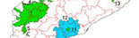
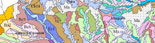
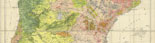
ZOOM EFFECT: the degree of accuracy of a soil map
When using digital maps it is important to take into account the fact that:
– despite appearing to be completely homogenous, as they are presented with
delineations of the same colour or symbol, polygons may have
inclusions which cannot be represented. The minimum surface area
that can be represented on the map with the map remaining legible
is a 5 mm square.
– although the limits between delineations (polygons) are represented
on the map by a line, they should not be interpreted as
discontinuities in a landscape, as the lateral variation
of the soils is gradual. Furthermore, the positions of the
different limits relate to a specific degree of precision
and an acceptable degree of error, although the latter has
been considerably reduced since GPS systems became available.
– in order to increase the predictive capacity of a map it is necessary
to return to the field and increase the density of observations.
Zooming in and increasing the surface area of each delineation
on a soil map (and apparently its scale) using computer technology
does not automatically imply a parallel increase in the quality or
predictive capacity of the map in question.
|