The digital interface constitutes a new line of access to soil information, both in terms of what is purely descriptive and its representation of information on maps.
 The barrier that has traditionally limited access to map data may be considerably reduced if a series of tools are used which permit the adoption of suitable criteria that foster homogenization and flexibility. Nowadays, virtually all soil map data are stored in accordance with established protocols. This permits a degree of reproducibility which was unimaginable with the technology available only a few decades ago.
The technical tools which have contributed to the appearance of this new model for the management of cartographic information are:
 – The generalized use of
high-performance, high-capacity
personal computers.
– Techniques of map and
alphanumerical data
incorporation and
storage in high-capacity
and quick-recovery systems.
– The generalized and increased
availability and use of Global
Positioning Systems (GPS).
– The dissemination, ease of access to and speed of the global network, Internet.
 Even so, this change of formats requires a progressive adaptation that is unlikely to fully replace traditional approaches and presentations. Traditional methods have not been totally displaced, but rather complemented and completed and effectively made available to a much wider range of users.
Consequently, this has not involved a change in the way that soil information is managed and interpreted, which has essentially remained the same in terms of its key concepts. Instead, it has opened up new possibilities for disseminating information, which could have a considerable impact in terms of making the uses of all kinds of soil information much more widely available.
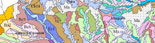
SOIL MAPS AND MANAGEMENT UNIT MAPS
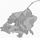
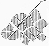
The delineations represented on a soil map have irregularly-shaped limits that could potentially pose a problem for some uses. This information must therefore be transformed into more regular units, grouping together soil delineations that offer similar responses to the proposed uses.
|
A map systemized by a specialist: management units and access to plots.
(The corresponding legend is not indicated)
(Porta, J. et. al. Edafología para la agricultura y el medioambiente. Ed. Mundi Prensa, 929 pp. Madrid, 2005).
|