|
|
DEGRADATION AND CONTROL PROCESSES |
|
Degradation process:
|
Related to building activities that do not envisage topsoil removal and reuse.
|
Description:
|
Topsoil removal consists of removing the upper layer of soil (edaphic matter) prior to any subsequent action on a specific plot. The upper soil layer, which has the best structure and is the richest in organic matter, nutrients, autochthonous plant seeds, micro-organisms and fauna will otherwise be lost.
|
Click on the image
|
Click on the image
|
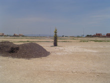
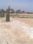
Work on building land without previous removal of the topsoil: a horizon of calcium carbonate has been left on the surface: this does not favour the implantation of vegetation, which requires the presence of compost.
Segrià ( J. Porta)
|
Biomass production, which requires more inputs (important in cases of revegetation of rehabilitated areas and more ecological gardening). Hydrological function, genetic reserves of autochthonous plants (important in the rehabilitation of former opencast mining sites), aesthetic and landscaping function.
|
Before taking any action on land destined for building, the soil must be removed and later returned to open areas. This makes it possible to ensure a much more favourable medium for plant growth (gardens, natural or agricultural areas) with lower input requirements.
|
Click on the image
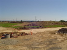
Building activity associated with topsoil removal,
stockpiling and reuse, which facilitates revegetation.
Lleida (J. Porta)
|
|
<< back |
|
|
|


;)
;)
;)