|
|
DEGRADATION AND CONTROL PROCESSES |
|
Degradation process:
|
Sheet erosion or inter-rill erosion. Water erosion by diffuse surface runoff.
|
Description:
|
Loss of a, more or less uniform, thin layer of soil (splash detached particles) from a slope. This occurs when rainfall intensity exceeds infiltration or when the soil becomes waterlogged, which gives rise to an excess of surface water. Surface runoff transports away the finest particles which leads to a progressive reduction in soil productivity (loss of clay, organic matter and nutrients). Surface crusting favours surface runoff.
Importance: great in arid and semi-arid regions.
|
Click on the image
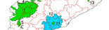
Inter-rill erosion. Conca de Tremp
(J. Porta)
|
Soil functions affected:
|
Biomass production (reduction of crop yields and need for greater inputs), environmental functions (filtration), hydrological function, reduction of carbon sequestration, functions for preventing offsite effects (deposition of sediments during floods, silting up of dams).
|
Diagnostic criteria:
|
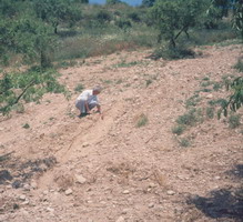
Not very apparent, so this may go unnoticed, despite its importance. After rainfall, coarse surface elements appear very clean. Accumulation of soil erosion matter around obstacles situated transversally downstream from the slope.
|
Click on the image
Surface stoniness due to the elimination of finer matter by sheet erosion on soils situated at the top of a slope and accumulation of soil matter at the foot of the slope.
Les Garrigues (J. Porta)
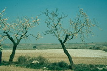
Click on the image

Inter-rill erosion: the soils at the top of the slope are more seriously affected, as reflected in the poor growth of vines
(C. Roquero)
|
Prevention and control:
|
Prevent splash erosion. Maintain plant cover. Prevent crusting. Protect surface soils with geotextiles or mulch. Implement cultivation techniques which create a rough soil surface or apply conservation measures that reduce the length of slopes and allow controlled drainage of rain water. Terracing and channel design should be calculated and projected according to the characteristics of local rainfall and the morphology of the terrain to limit erosion due to runoff.
|
|
<< back |
|
|
|


;)
;)
;)