|
|
DEGRADATION AND CONTROL PROCESSES |
|
Degradation process:
|
Due to waterlogging.
|
Description:
|
Intense rains can cause flooding which affects crops and buildings in flood-prone areas.
Continuous waterlogging may cause root anoxia, which affects sensitive crops. Floods are frequent in areas close to rivers, where they may create important problems, particularly - as in many cases when potential flood hazards have been ignored and flood plains have been occupied and built on.
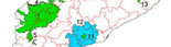
Importance: localized to flood-prone river margins.
|
Soil functions affected:
|
Biomass production (reduction of crop yields and even plant death due to root asphyxia), environmental functions (filtration), hydrological function (infiltration), functions of providing support for buildings (effects of floods).
|
Diagnostic criteria:
|
Mainly correspond to flood plains and flat valley bottoms.
|
Prevention and control:
|
Areas at risk of flooding and waterlogging should be mapped on hazard maps in order to provide relevant information for planners and those assigning land uses.
|
Click on the image
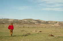
The risk of flooding is an important criterion for those assigning land uses, whether that be for housing or, as in this case, for preventing the death of peach trees. Segrià, Catalonia, Spain (J. Porta)
Click on the image
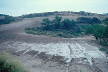
Sediment deposits in a waterlogged area due to the accumulation of surface runoff water in La Segarra (Lleida, Catalonia, Spain) (J. Porta)
|
|
<< back |
|
|
|


;)
;)