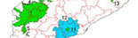
links of interest

information of interest

documents of interest


start

sitemap


SOIL PROTECTION Catalunya - the Balearic Islands / Principality of Andorra


soil protection (general information)


Vienna Soil Declaration


soil functions

sustainability criteria

degradation and control processes

soil protection criteria

soil quality indicators

soil maps

what is soil information used fort?

the purpose of soil maps

soil series and correlation

characteristics of a soils map

management and interpretation of soil information on a digital interface

Soil Series and Soil Types catalogue of Catalonia

presentation

criteria

soil Types (> 2010)

soil Series (1993 - 2009)

CCHARACTERISTICS OF A MAP

MAP SCALE

The scale of a map is defined as the quotient of the horizontal distance between two points on the map and the same two points on the ground.

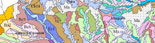
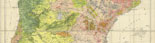
The larger the denominator, the smaller the scale. For example, maps at a scale of 1:25 000 are detailed whereas those at 1:250 000 are small scale maps.


RANGE OF SCALES

DENOMINATION SCALE / MAP

BASE MAP UNIT

Less than 1:500 000

Very small / exploratory

> 625 ha

100 000 - 500 000

Small / survey

25 - 625 ha

25 000 - 100 000

Medium / semi-detailed

1,5 - 25 ha

10 000 - 25 000

Large / detailed

2 500 - 15 625 m2

Greater than 10 000

Very large / intensive

< 2 500 m2


The larger the scale of a map, the smaller the spatial variability of the map units represented (greater degree of purity): large scale maps are therefore more interesting for making predictions and appropriately assigning land uses.


<< back

map of mapped areas

maps of existing soil

search by municipality / parishes

search by quadrate

small scale maps and maps of historical interest

bibliographical references

soils in images