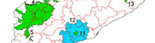
MAP QUALITY CRITERIA
Soil map quality criteria refer to:
– Accuracy:this depends on the graphic error in the localisation of the
cartographic units on the map. Accuracy increases with the density
of observations, if the map indicates cartographic and topographical
references and coordinates and if the background is the ortophotomap
of the area. It is import to establish the limits between the
different units.
– Expression: Expression: appropriate presentation of the information. This
depends on the symbols, colours, shading and signs, which must be
selected with care. The map must be easy on the eyes.
– Legibility: Legibility: the ease with which the information can be taken in. This
depends on the soil distribution pattern. It is important to choose the optimal
representation of scale. An excess of information may make the map difficult to
use.For questions relating to publishing costs, maps are normally produced for
the smallest scale possible, as long as they remain readable and information
they contain is not lost in reduction.
A map must be clear: the use of colours
and symbols on each map representation has
an important influence on legibility.
– Efficiency: the map must be useful, complete and reliable.
The information contained on the map must make it possible to predict the soil
properties in any of the units represented. This depends on the purity of each
map unit, in other words, on the scale.
– The legend: this presents the map units in an organized way.
It allows the map to be used as a document that is complete in itself.
It must be short, useful and easily understood. The legend must be identificative,
if there is only a list of symbols by which to identify units by name; descriptive,
if it provides information on each unit; and interpretative, if it provides
information on each unit in relation to specific land uses or management systems.
It should
facilitate access to the information without the user having to be a
specialist. The legend can include references to sources of documentation,
work method, inclusions and accuracy.
|